|
Picture: the windmill of Doel from the embankment of the Scheldt with the nuclear plant on the background |
|
» Hooghuis » Windmill » Church » Full overview... » Scheldt banks » Harbour » Nuclear plant » Full overview...
|
Doel
Short history. Doel was already mentioned in the 13th century; the surroundings here were swampy and mudflat. The area flooded regularly (remains of this can still be seen north of the village in the nature reserve "het verdronken land van Saeftinghe", the drowned land of Saeftinghe). To counter the floods, dikes were built and drainage works performed. All this however did not prevent the occasional flood afterwards though. Shortly before the outbreak of the 80-years war (1568-1648), the dikes around Doel were strengthened. During that war, the area around the village was flooded for strategic reasons. During the 12-years truce (1609-1621), the village was built entirely according to a plan. This is why the street pattern is so geometrical, something that is quite exceptional in Flanders.
Doel was an independent community until 1977, after which it became a part of the community of Beveren. How to reach Doel? This is best done with own transport. Take exit "Doel" on the E34.
Links.
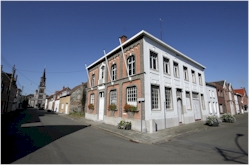
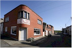
Picture 1: the former community hall
of Doel
|
» How to get to Doel » Links » Beveren » Doel » Haasdonk » Kallo » Kieldrecht » Melsele » Prosperpolder » Verrebroek » Vrasene
|
 General.
Doel is the last Belgian village on the left bank of the river
Scheldt and is mainly known for its nuclear plant and the fact
that it is about to dissapear. The entire village and the
surrounding fertile polderlands have to give way for the
expansion of the port of Antwerp on the left bank of the river.
Since several years already, houses and farms are being torn
down systematically, which resulted in the village receiving the
non-enviable status of ghost village. The pictures here were
taken in 2007 and 2008; the view of the place has changed
dramatically since then, so if you still want to see a bit of it,
don't wait too long.
General.
Doel is the last Belgian village on the left bank of the river
Scheldt and is mainly known for its nuclear plant and the fact
that it is about to dissapear. The entire village and the
surrounding fertile polderlands have to give way for the
expansion of the port of Antwerp on the left bank of the river.
Since several years already, houses and farms are being torn
down systematically, which resulted in the village receiving the
non-enviable status of ghost village. The pictures here were
taken in 2007 and 2008; the view of the place has changed
dramatically since then, so if you still want to see a bit of it,
don't wait too long. And
the water of the Scheldt river flowed on peacefully alongside
the dikes of the dikes in Doel until the sixties of the previous
century. Then plans were unveiled to expand the port of Antwerp
on the left bank of the river. Doel seemed to face the same fate
as the villages of Oosterweel, Oorderen, Lillo and Wilmarsdonk
on the opposite side of the Scheldt river that have dissapeared
of the face of the earth due to the same reason. The inhabitants
of Doel resisted and the plans were stored away. At least for
the time being. In the nineties however, the fright of Doel
reappeared. Despite the resistance of the remaining inhabitants,
various houses and farms have been torn down to give room to the
Deurganckdocks (constructed in the meantime) and the planned
Saeftinghedocks.
And
the water of the Scheldt river flowed on peacefully alongside
the dikes of the dikes in Doel until the sixties of the previous
century. Then plans were unveiled to expand the port of Antwerp
on the left bank of the river. Doel seemed to face the same fate
as the villages of Oosterweel, Oorderen, Lillo and Wilmarsdonk
on the opposite side of the Scheldt river that have dissapeared
of the face of the earth due to the same reason. The inhabitants
of Doel resisted and the plans were stored away. At least for
the time being. In the nineties however, the fright of Doel
reappeared. Despite the resistance of the remaining inhabitants,
various houses and farms have been torn down to give room to the
Deurganckdocks (constructed in the meantime) and the planned
Saeftinghedocks. 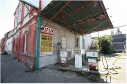
|
©
xplorengo.com. No information or pictures can be copied or distributed in any way
without written permission of xplorengo.com.
|